Not much snow fell in Douglas County from this latest front that moved through last night and this morning. Canyon Pass along I-5 and a few other areas got a little bit of snow. Late this afternoon the next front arrives and could possibly bring a dusting of snow by Monday morning. Things will definitely be colder tomorrow morning so be careful of icy roads. Below is the latest advisory issued: Winter Weather Advisory *NOAA Issue Date: 2/2/2020 09:04:00 AM Low elevation snow into early Monday morning ... . Snow levels near or at the Valley floors will stay low into early Monday morning. Precipitation amounts will be light, but at least a dusting of snow is expected for nearly all of southwest Oregon, with the exception of the immediate coast. Less widespread coverage is also expected for south central Oregon and northern California. Ice could easily develop on any wet roads with cold temperatures tonight. Colder temperatures will follow Monday night. * What Snow expected. Total snow accumulations of a trace to 2 inches are forecast for area valleys, with 3 to 5 inches above 2000 feet. The lowest amounts will be on the Valley floors. * Where Generally above 700 feet west of the Cascades, including the cities of Medford, Shady Cove, Ashland, Rogue River, Jacksonville, Ruch, Cave Junction, Camas Valley, Tiller, and Glendale. This includes much of the interstate 5 corridor, especially over area passes, and portions of highways 199, 140, 62, 138, and 42. * When Through 4 AM PST Monday. Snow showers will not end, but coverage will be at a minimum late this morning into the early afternoon. Snow showers will become more frequent after 3 PM PST. * Impacts Travel could become difficult due to low visibility and slick roadways, especially over passes and along steeper slopes. * Additional details Cold temperatures could refreeze snowmelt, leading to icy roads early next week. * View the hazard area in detail at https://www.wrh.noaa.gov/mfr/hazard Precautionary/preparedness actions...
Next Weather Front Arrives Sunday Late Afternoon
Related


Stay up to date
Get new posts from Roseburg Tracker in your inbox.
More Stories

In Memory of John Lindsey
John Payne Lindsey, 79, of Roseburg, Oregon, was unexpectedly called home to heaven on Dec. 12, 2025, surrounded by his family. John was born March 19...
2 min read
Roseburg Man Charged With Murder of 11-Month-Old Son
DOUGLAS COUNTY, Ore. – A Roseburg man is in custody tonight charged with the murder of his 11-month-old son. On Sunday, March 15, 2026, shortly befor...
2 min read
K9 Nike to Retire From Winston Police Department
Winston Police Dog Retires After Eight Years of service.
1 min read
Roseburg Cuts Ribbon on New Outdoor Tennis and Pickleball Facility
Roseburg’s rebuilt outdoor Stewart Park complex is now open with eight tennis courts and 10 pickleball courts.
3 min read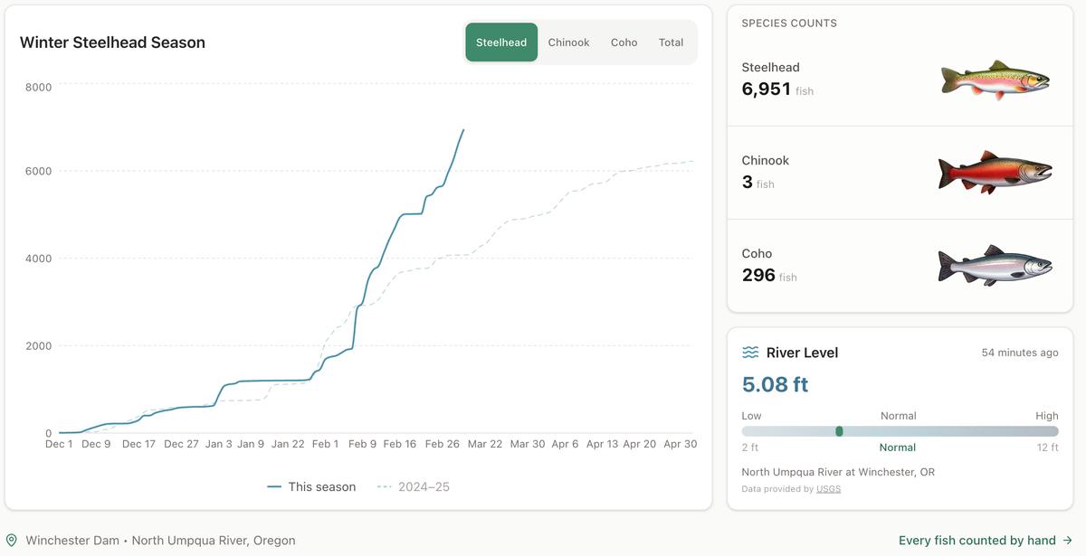
Winter Steelhead Run on the North Umpqua Surpasses Last Year's Total
Nearly 7,000 fish counted at Winchester Dam with two months left in the season
1 min read
Oregon Faces Challenges After Mild Winter
A mild winter has left Oregon with reduced snowpack heading into spring, raising concerns about river levels and insect activity later this year.
1 min read
Stay informed
Get the latest stories from Roseburg Tracker delivered straight to your inbox.