The Archie Creek Fire is now 121,379 acres an increase of 5,522 acres over the past day or so. Reminder, on these IR fire maps. The maps are meant to inform on approximate boundaries, not the specific case by case property status. Hope these are helpful! Here are the latest notes from the IR flight that took place overnight. “Areas of intense heat and heat perimeter growth were detected around the majority of the heat perimeter tonight. One large area of growth is south of the Umpqua River, east of Glide, near Peel where the heat is backing down off the hills to the north (Bob Butte and Buck Rock). To the east, intense heat is on both sides of Shivigny Mountain and expanding eastward. To the east, north of the Umpqua River, the fire is cooler, without much expansion. East of Panther Ridge within the National Forest, intense heat is moving downhill, with a number of isolated areas of heat. The far SE part of the fire had a large area of perimeter growth with intense heat along the south banks of the North Umpqua River east of Panther Ridge. Continuing to the north along the east side of the perimeter, there was growth along the Steamboat Point area, but no intense heat. NW of there, the heat is backing down into the Canton Creek drainage, from Bloody Point to the NW to Trapper Creek. To the west, there were two larger areas of very intense heat, one on the north side of the East Fork Rock Creek and in the upper part of the Surprise Creek drainage. Intense heat is backing down the knob between Hurry Up Creek and Northeast Fork Rock Creek. Continuing to the east, there are several areas of intense heat backing downhill into the main Rock Creek drainage. To the northwest, there is some heat perimeter growth on the south side of South Fork Calapooya Creek. On the west part of the perimeter, there was perimeter expansion to the east and uphill of the community labelled Hawthorne. Further to the SW, the heat is backing down into Hinkle Creek, where structures are shown on the topo map. Along the rest of the western perimeter, areas of intense heat were detected near Field Creek, Slide Creek and Gassy Creek. To the south, there were small areas of heat perimeter growth in the upper reaches of Huntley Creek. From there down to Glide, the perimeter was relatively cool, with very minimal growth.”
Sunday Morning Archie Creek Fire Update: Fire Growth Continues to Slow
Related


Stay up to date
Get new posts from Roseburg Tracker in your inbox.
More Stories

In Memory of John Lindsey
John Payne Lindsey, 79, of Roseburg, Oregon, was unexpectedly called home to heaven on Dec. 12, 2025, surrounded by his family. John was born March 19...
2 min read
Roseburg Man Charged With Murder of 11-Month-Old Son
DOUGLAS COUNTY, Ore. – A Roseburg man is in custody tonight charged with the murder of his 11-month-old son. On Sunday, March 15, 2026, shortly befor...
2 min read
K9 Nike to Retire From Winston Police Department
Winston Police Dog Retires After Eight Years of service.
1 min read
Roseburg Cuts Ribbon on New Outdoor Tennis and Pickleball Facility
Roseburg’s rebuilt outdoor Stewart Park complex is now open with eight tennis courts and 10 pickleball courts.
3 min read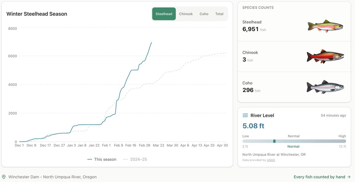
Winter Steelhead Run on the North Umpqua Surpasses Last Year's Total
Nearly 7,000 fish counted at Winchester Dam with two months left in the season
1 min read
Oregon Faces Challenges After Mild Winter
A mild winter has left Oregon with reduced snowpack heading into spring, raising concerns about river levels and insect activity later this year.
1 min read
Stay informed
Get the latest stories from Roseburg Tracker delivered straight to your inbox.