After 14 weeks or so of dry weather, rain is finally expected starting Thursday. Close to a 1/2 of rain is expected to fall in Douglas County according to NWS out of Medford. Thunderstorms are possible as well. Be very careful on the roads as a lot of oil has built up. Here is the full report from the NWS Medford. (NWS) KEY POINTS ● Smoke at the coast has cleared and no significant smoke there through Sat at least. ● Heavy smoke over inland areas west of Cascades. Some improvement expected late this afternoon and again Thursday afternoon. Best chance for healthy conditions Friday afternoon (see attached imagery). ● Red Flag Warning for gusty winds and low humidity east of Cascades this afternoon and Thursday afternoon. ● Thunderstorms possible Thursday afternoon/evening primarily Jackson, Josephine, and Douglas Counties. Some storms could be severe and bring strong winds, hail, and brief periods of heavy rainfall. Heavy rain on any burn scars can wash debris onto roadways. ● Mt Ashland RADAR will be down for required maintenance into next week, and staff at Medford NWS will be utilizing additional data sources to help protect life and property ● There is some uncertainty in terms of how much smoke will impact thunderstorm development. ● Rainfall chances begin Thursday from Cascades westward with better chances for wetting rainfall Friday from Cascades westward including Western Siskiyou County. ● Roads could become especially hazardous/slippery due to oil buildup after near-record streak of dry weather in the region (see attached imagery) ● From the Cascades westward, no hot, dry, windy events are expected through at least the middle of next week. Multiple major wildfires are ongoing in the region, and we are experiencing historically poor air quality in our forecast area. Little improvement has occurred away from the coast due to a rather stagnant weather pattern. That will change soon as we have a significant low approaching from the west Thursday and moving overhead Friday. Rain chances and higher humidity are good news for the overall fire and smoke situation, but there are hazards that will accompany this change. First, thunderstorms are possible Thursday afternoon/evening, primarily over Josephine, Jackson, and Douglas Counties. Some of these could become severe with strong winds, frequent lightning, and large hail. Second, much of Southern Oregon has not received rainfall in over 90 days. Oils can build up on roadways, and during first rainfall, roads can become especially slippery. Third, if any storms produce heavy rain over wildfire burn scars, debris can be washed onto nearby roadways.
Rain & Thunderstorms Expected Thursday and Friday in Douglas County
Related


Stay up to date
Get new posts from Roseburg Tracker in your inbox.
More Stories
 New
NewIn Memory of John Lindsey
John Payne Lindsey, 79, of Roseburg, Oregon, was unexpectedly called home to heaven on Dec. 12, 2025, surrounded by his family. John was born March 19...
2 min read New
NewRoseburg Man Charged With Murder of 11-Month-Old Son
DOUGLAS COUNTY, Ore. – A Roseburg man is in custody tonight charged with the murder of his 11-month-old son. On Sunday, March 15, 2026, shortly befor...
2 min read
K9 Nike to Retire From Winston Police Department
Winston Police Dog Retires After Eight Years of service.
1 min read
Roseburg Cuts Ribbon on New Outdoor Tennis and Pickleball Facility
Roseburg’s rebuilt outdoor Stewart Park complex is now open with eight tennis courts and 10 pickleball courts.
3 min read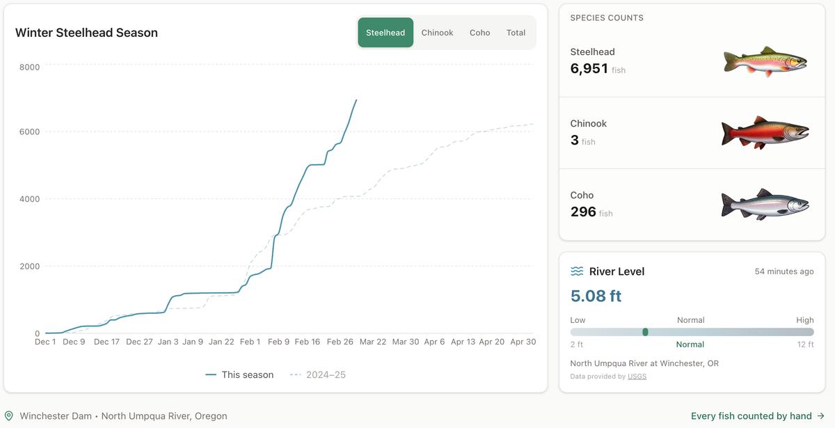
Winter Steelhead Run on the North Umpqua Surpasses Last Year's Total
Nearly 7,000 fish counted at Winchester Dam with two months left in the season
1 min read
Oregon Faces Challenges After Mild Winter
A mild winter has left Oregon with reduced snowpack heading into spring, raising concerns about river levels and insect activity later this year.
1 min read
Stay informed
Get the latest stories from Roseburg Tracker delivered straight to your inbox.