Douglas County is going to see very active weather over the next few days. High winds will return tonight with winds up to 28 mph and gusts up to 55 mph late tonight into Monday. Here is the full wind advisory from NWS. ...WIND ADVISORY REMAINS IN EFFECT UNTIL 1 PM PST MONDAY... * WHAT...South winds 20 to 30 mph with gusts up to 55 mph expected. The highest and most exposed terrain in the Coast Range may see gusts up to 70 mph on tonight. * WHERE...Southern Douglas County and Eastern Curry County and Josephine County including Highway 199 near Selma, Azalea, Glendale, Sexton Pass on Interstate 5. * WHEN...Until 1 PM PST Monday. A break is ongoing, but winds will begin again tonight. * IMPACTS...Gusty winds could blow around unsecured objects. Tree limbs could be blown down and a few power outages may result. Driving will become difficult, especially for high profile vehicles. Heavy Rain and Snow Hazardous travel conditions are expected across Southern Oregon and Northern California Monday. At the coast, heavy rain is expected in the morning, and mountain pass snowfall is expected generally above 4000 feet with lowering snow levels late Monday. Widespread windy conditions are expected. High Surf Dangerous high surf along southern Oregon beaches and shorelines will continue through Tuesday, with additional periods of high surf likely through the week. Surf heights will remain near peak values of 25-28 feet. Beach erosion is possible, as well as damage to exposed infrastructure. Beachgoers should stay off of jetties, rocks, and logs. Beachcombing is strongly discouraged.
High Winds Tonight, Heavy Rains Tomorrow, and Lots of Mountain Snow on the Way
Related


Stay up to date
Get new posts from Roseburg Tracker in your inbox.
More Stories

In Memory of John Lindsey
John Payne Lindsey, 79, of Roseburg, Oregon, was unexpectedly called home to heaven on Dec. 12, 2025, surrounded by his family. John was born March 19...
2 min read
Roseburg Man Charged With Murder of 11-Month-Old Son
DOUGLAS COUNTY, Ore. – A Roseburg man is in custody tonight charged with the murder of his 11-month-old son. On Sunday, March 15, 2026, shortly befor...
2 min read
K9 Nike to Retire From Winston Police Department
Winston Police Dog Retires After Eight Years of service.
1 min read
Roseburg Cuts Ribbon on New Outdoor Tennis and Pickleball Facility
Roseburg’s rebuilt outdoor Stewart Park complex is now open with eight tennis courts and 10 pickleball courts.
3 min read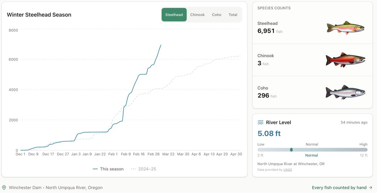
Winter Steelhead Run on the North Umpqua Surpasses Last Year's Total
Nearly 7,000 fish counted at Winchester Dam with two months left in the season
1 min read
Oregon Faces Challenges After Mild Winter
A mild winter has left Oregon with reduced snowpack heading into spring, raising concerns about river levels and insect activity later this year.
1 min read
Stay informed
Get the latest stories from Roseburg Tracker delivered straight to your inbox.