Rough Patch Complex 14,587 acres, 3% contained Chaos and Little Bend Fires: The primary containment lines of these fires lay on the west and northwest flanks. Direct fire line construction and indirect fire lines with burnout operations are occurring in these areas of the fire. On the west and south flanks of these fire the primary containment lines are at the perimeter of the fire and heavy equipment is working to construct and reinforce alternate and contingency lines. These two fires are at 0% containment, but progress is being made. Jack Fire 23,692 acres, 51% contained Jack Fire: The Jack Fire does have containment lines that are holding on the west and north flanks of the fires and these account for the 51% containment of the fire. Fire crews are patrolling these flanks and taking action to hold the lines as necessary. The southwest and south flanks of the fire is seeing active fire behavior – tactics on these flanks include direct dozer line, the construction of primary and alternate lines using the road system and building and reinforcing contingency lines along the 27 and 2715 roads. The northeast part of the fire actively burn on Monday and increased the overall fire size by approximately 2,000 acres. Buckhead and Near Minky Fires: These fires lay south of the Jack fire and have similar active fire behavior on the west flanks. The contingency line being constructed with heavy equipment for the Jack fire will extend to the south and act as the primary holding line to prevent these fires from moving to the west. On the south and east flanks of these fire, heavy equipment is working to build fire line to hold and prevent fire from escaping to the south and east. Overall Objective: The Rough Patch Complex and Jack Fire are being managed under a full suppression strategy using containment and confinement tactics to minimize fire spread to prevent loss of valuable resource. Leaders’ intent is to not allow the fire to progress to the west by using the PACE model – Primary, Alternate, Contingency and Emergency control Lines and to keep the fires as small as possible while working toward full containment. Closures: The Umpqua and Willamette National Forests have updated existing closure orders to encompass the Rough Patch, Jack, Archie Creek and Devil's Knob Fire Areas. This includes Canton Creek Campground, Musick Guard Station and Cover Campground. Roseburg District Bureau of Land Management has expanded its closure area to include the Scaredman Recreation Site. Francis Creek Road from the junction with Canton Creek Road north to the district boundary has been and remains closed since August 5. Highway 138 between Roseburg and Diamond Lake and Crater Lake remains open. Slow down and be alert while passing through the fire area. Copies of all closures and maps can be found at https://inciweb.nwcg.gov/incident/closures/7758/ WEATHER: weather conditions are trending to more seasonal like conditions with better overnight Rh recoveries, but still hot. Stronger winds from the west/northwest are forecasted which will increase fire behavior.
Jack Fire and Rough Patch Complex Up To 38,279 Acres Combined
Related


Stay up to date
Get new posts from Roseburg Tracker in your inbox.
More Stories

In Memory of John Lindsey
John Payne Lindsey, 79, of Roseburg, Oregon, was unexpectedly called home to heaven on Dec. 12, 2025, surrounded by his family. John was born March 19...
2 min read
Roseburg Man Charged With Murder of 11-Month-Old Son
DOUGLAS COUNTY, Ore. – A Roseburg man is in custody tonight charged with the murder of his 11-month-old son. On Sunday, March 15, 2026, shortly befor...
2 min read
K9 Nike to Retire From Winston Police Department
Winston Police Dog Retires After Eight Years of service.
1 min read
Roseburg Cuts Ribbon on New Outdoor Tennis and Pickleball Facility
Roseburg’s rebuilt outdoor Stewart Park complex is now open with eight tennis courts and 10 pickleball courts.
3 min read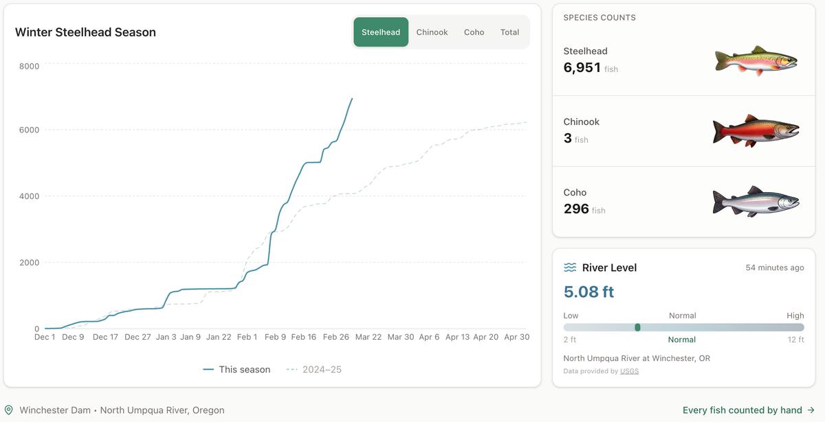
Winter Steelhead Run on the North Umpqua Surpasses Last Year's Total
Nearly 7,000 fish counted at Winchester Dam with two months left in the season
1 min read
Oregon Faces Challenges After Mild Winter
A mild winter has left Oregon with reduced snowpack heading into spring, raising concerns about river levels and insect activity later this year.
1 min read
Stay informed
Get the latest stories from Roseburg Tracker delivered straight to your inbox.