The Diamond Lake area currently has about 8 inches of snow on the ground. Snow levels will drop from 7000 feet to as low as 2500 feet behind a front expected to arrive Saturday. This will bring moderate to localized heavy snow, mainly in the Cascades and Western Siskiyou County, and could lead to disruption of traffic at mountain passes. This graphic shows an image of heavy snow in the mountains with snow totals up to a foot in the Cascades. Up at Crater Lake, the park has closed Rim Drive, North Entrance and Pinnacles Roads for the winter season. Here is the latest forecast discussion from the NWS. Tonight November 2 through Friday night November 4... The most immediate change was to extend the Winter Weather Advisory /PDXWSWMFR/ for the southern Oregon Cascades and Siskiyous through 8 PM PDT this evening. Showers and snow showers will linger this evening, particularly early this evening along and near northwest facing slopes such as the Cascades and the Umpqua Divide with up to 2 inches of new snow. Light snow showers are also expected for much of south central Oregon and northern California with up to an inch of new accumulation. The snow level is around 2500 to 3000 ft msl and will drop as low as 2000 feet by the time that activity tapers off at the end of the evening. Thursday will be the closest thing to a true break in the active, wet pattern with shortwave ridging into our area, associated with a broader area of high pressure centered far offshore from California. With a stabilizing air mass and lingering low level moisture, valley stratus and patchy freezing fog is expected late tonight into Thursday morning. This will be mainly in west side valleys, and in the Klamath Basin. It will be colder Thursday morning with west side lows in the lower 20s to mid 30s, and east side lows in the single digits to lower teens. Lows will be around 5 to 15 degrees below normal, and within about 10 degrees of records on the east side. By the end of Thursday afternoon, there is a slight chance of rain at the coast from Port Orford northward and inland to around Elkton from a warm front pushing into the Pacific Northwest. This front will focus its energy into Washington and northern Oregon, with the highest probability of rain in our area for Coos and Douglas counties, secondarily for Curry County Thursday night through Friday. Rainfall amounts in those areas will be mainly up to a tenth of an inch, with very light amounts possible elsewhere. Snow levels will rise from around 4000 feet Thursday evening to 7500 feet by the start of Friday evening. There is a growing consensus in the ensemble data for a strong cold front to push southeast into our area beginning Friday night, initially affecting the coast and Douglas County during Friday evening. Moderate to heavy precipitation and strengthening winds are expected later Friday night with snow levels remaining quite high, above 6500 feet msl. During Friday night, the most intense precipitation is expected in western and central Oregon. This includes southwest Oregon and northern Klamath County beginning after midnight. -DW Photos courtesy of Ginger Finch
Diamond & Crater Lake to Receive Significant Snowfall This Week
Related


Stay up to date
Get new posts from Roseburg Tracker in your inbox.
More Stories

In Memory of John Lindsey
John Payne Lindsey, 79, of Roseburg, Oregon, was unexpectedly called home to heaven on Dec. 12, 2025, surrounded by his family. John was born March 19...
2 min read
Roseburg Man Charged With Murder of 11-Month-Old Son
DOUGLAS COUNTY, Ore. – A Roseburg man is in custody tonight charged with the murder of his 11-month-old son. On Sunday, March 15, 2026, shortly befor...
2 min read
K9 Nike to Retire From Winston Police Department
Winston Police Dog Retires After Eight Years of service.
1 min read
Roseburg Cuts Ribbon on New Outdoor Tennis and Pickleball Facility
Roseburg’s rebuilt outdoor Stewart Park complex is now open with eight tennis courts and 10 pickleball courts.
3 min read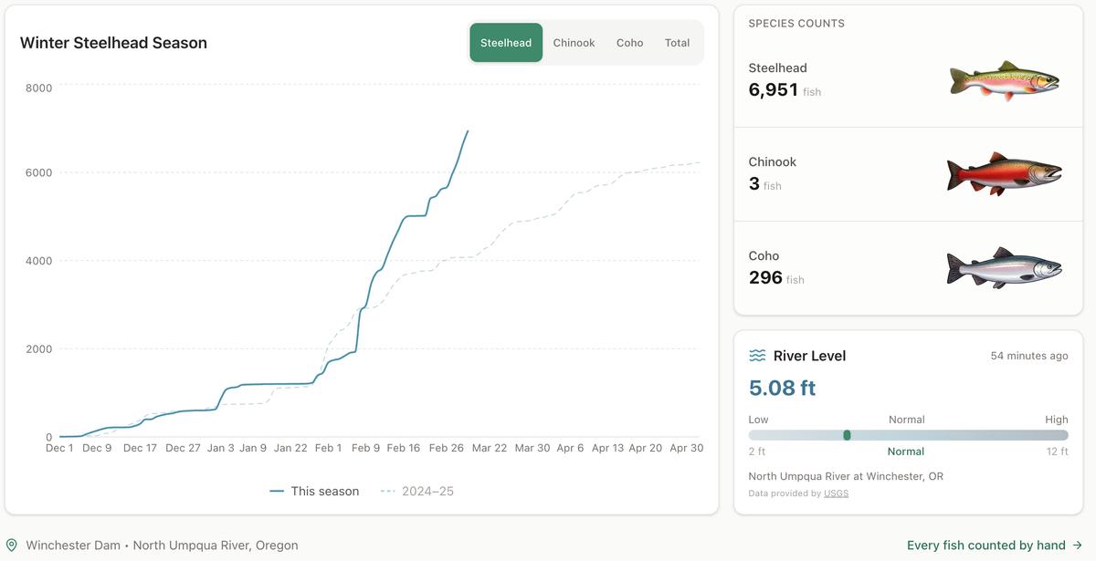
Winter Steelhead Run on the North Umpqua Surpasses Last Year's Total
Nearly 7,000 fish counted at Winchester Dam with two months left in the season
1 min read
Oregon Faces Challenges After Mild Winter
A mild winter has left Oregon with reduced snowpack heading into spring, raising concerns about river levels and insect activity later this year.
1 min read
Stay informed
Get the latest stories from Roseburg Tracker delivered straight to your inbox.