The valley floors in Southern Oregon could see as much as an inch of snow tonight into early Monday morning before snow levels rise again. At higher elevations in the Cascades, another 6-12 inches of snow is expected through Monday. Here is the latest forecast from the NWS in Medford: The Winter Weather Message was updated this morning, and Advisories or Warnings are now in effect for much of the foothills and mountains above 1,500 feet through this evening. Snow levels are expected to lower to 1,000 feet into Monday morning. Meanwhile, most valley locations will receive up to an inch of snow through Monday morning. Precipitation Details: Highest rates of precipitation will be west of the Cascades and during this afternoon. Snow levels will be around 3,000 feet, falling to 2,000 feet. Additional snow showers are expected this evening into Monday morning. Snow levels will continue to fall to 500 to 1,200 feet. Further Forecast: Light low elevation snow showers are likely later Monday through Tuesday morning. Snow levels will rise to around 2,000 feet on Monday afternoon, then drop to 500 to 1,200 feet by Tuesday morning. A gradual warming trend is expected thereafter. The snowpack at Crater Lake is now around 5 feet higher than normal for this time of year. A big warming shift is set to begin arriving Wednesday of this next week and temperatures could be well into the 70's by next weekend. That could bring significant snow melt and raise river levels quite a bit. Something to keep an eye one.
Up to an Inch of Snow Possible for Valley Floors Tonight
Related


Stay up to date
Get new posts from Roseburg Tracker in your inbox.
More Stories

In Memory of John Lindsey
John Payne Lindsey, 79, of Roseburg, Oregon, was unexpectedly called home to heaven on Dec. 12, 2025, surrounded by his family. John was born March 19...
2 min read
Roseburg Man Charged With Murder of 11-Month-Old Son
DOUGLAS COUNTY, Ore. – A Roseburg man is in custody tonight charged with the murder of his 11-month-old son. On Sunday, March 15, 2026, shortly befor...
2 min read
K9 Nike to Retire From Winston Police Department
Winston Police Dog Retires After Eight Years of service.
1 min read
Roseburg Cuts Ribbon on New Outdoor Tennis and Pickleball Facility
Roseburg’s rebuilt outdoor Stewart Park complex is now open with eight tennis courts and 10 pickleball courts.
3 min read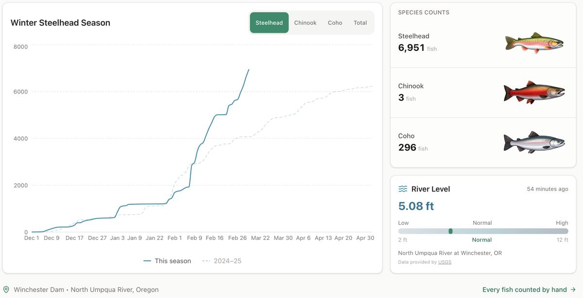
Winter Steelhead Run on the North Umpqua Surpasses Last Year's Total
Nearly 7,000 fish counted at Winchester Dam with two months left in the season
1 min read
Oregon Faces Challenges After Mild Winter
A mild winter has left Oregon with reduced snowpack heading into spring, raising concerns about river levels and insect activity later this year.
1 min read
Stay informed
Get the latest stories from Roseburg Tracker delivered straight to your inbox.