The weather is going to get pretty crazy over the next few days. First, on Friday, we could reach temperatures as high as 67 degrees in the Roseburg area. Then, a new system will abruptly arrive Saturday evening and drop snow levels from 7,000 to 1,000 feet by early Sunday morning. The snow levels will rise a little on Sunday during the day before dropping down to 500 feet later on Sunday night into Monday morning. Here is the weather discussion from NWS in Medford. PREV DISCUSSION... /Issued 300 AM PST Thu Jan 30 2020/ DISCUSSION...30/00Z EC in. 30/06Z NAM/GFS in. The Medford CWA will remain under progressive pattern into the weekend with several weak to moderate fronts moving onshore. The storm track will forced farther north with each system as ridging from the south becomes gradually stronger. A flat upper ridge remains over the area, and short waves riding over the top of the ridge pushed a cold front onshore last evening, and that front is now moving onshore. That front will likely not clear the Medford CWA before it moves back north as a warm front Thursday. Snow levels will bottom out in the 5000-6000 foot range, then rise back up to around 9000 feet Thursday. Another cold front will move onshore Thursday night, but by that time the storm track will be far enough north that it won`t amount to much in terms of winds and precipitation, and snow levels will remain quite high, generally 6000-7000 feet behind the cold front. High temperatures Friday could reach 10-15 degrees above normal for this time of year. The ridge will break to the east of the area Friday night, and a strong upper trough offshore will approach the west coast. A warm front will move north through the area Saturday with some light precipitation, mostly near the coast. Then the trough will push a strong cold front onshore Saturday night. This transition will be abrupt. Sunday highs will be around 10 degrees below normal. Snow levels will drop from around 7000 feet Friday to around 1000 feet Sunday morning, rise to around 1500 feet during the day Sunday, then dropping down to 500 feet or so Sunday night into Monday morning. Precipitation will be light for the most part and it will mostly by over by Monday morning. Confidence is high on snow levels, but low on the precipitation amounts and distribution. However, even a bit of snow can create large impacts at low elevations, and it will be cold enough for ice to form on roads as well. Stayed tuned for updates. Long Term discussion from the Wednesday afternoon AFD...Monday 03 Feb through Wednesday night 05/06 Feb 2020. High pressure will begin to build Monday morning with a very cold airmass still in place. It's so cold that models are still initiating some convective showers over the ocean and moving them over land. The air should be sinking and drying, so we're not expecting any rain or snow accumulation after Monday morning. High pressure will continue to build into Tuesday and we will probably see some clearing skies east of the Cascades and perhaps west of the Cascades as well. With the recent snowfall, temperatures should fall down into the lower and mid teens in Alturas, Lakeview and other locations east of the Cascades. The weather is then expected to change with a warm front pushing into southern Oregon around the Tuesday night into Wednesday timeframe. This front, and the weather it will bring, is not looking like a significant event for our region. It looks like the bulk of the rain will fall farther to the north.
Douglas County Could Receive Snow Sunday Morning
Related


Stay up to date
Get new posts from Roseburg Tracker in your inbox.
More Stories
 New
NewIn Memory of John Lindsey
John Payne Lindsey, 79, of Roseburg, Oregon, was unexpectedly called home to heaven on Dec. 12, 2025, surrounded by his family. John was born March 19...
2 min read New
NewRoseburg Man Charged With Murder of 11-Month-Old Son
DOUGLAS COUNTY, Ore. – A Roseburg man is in custody tonight charged with the murder of his 11-month-old son. On Sunday, March 15, 2026, shortly befor...
2 min read
K9 Nike to Retire From Winston Police Department
Winston Police Dog Retires After Eight Years of service.
1 min read
Roseburg Cuts Ribbon on New Outdoor Tennis and Pickleball Facility
Roseburg’s rebuilt outdoor Stewart Park complex is now open with eight tennis courts and 10 pickleball courts.
3 min read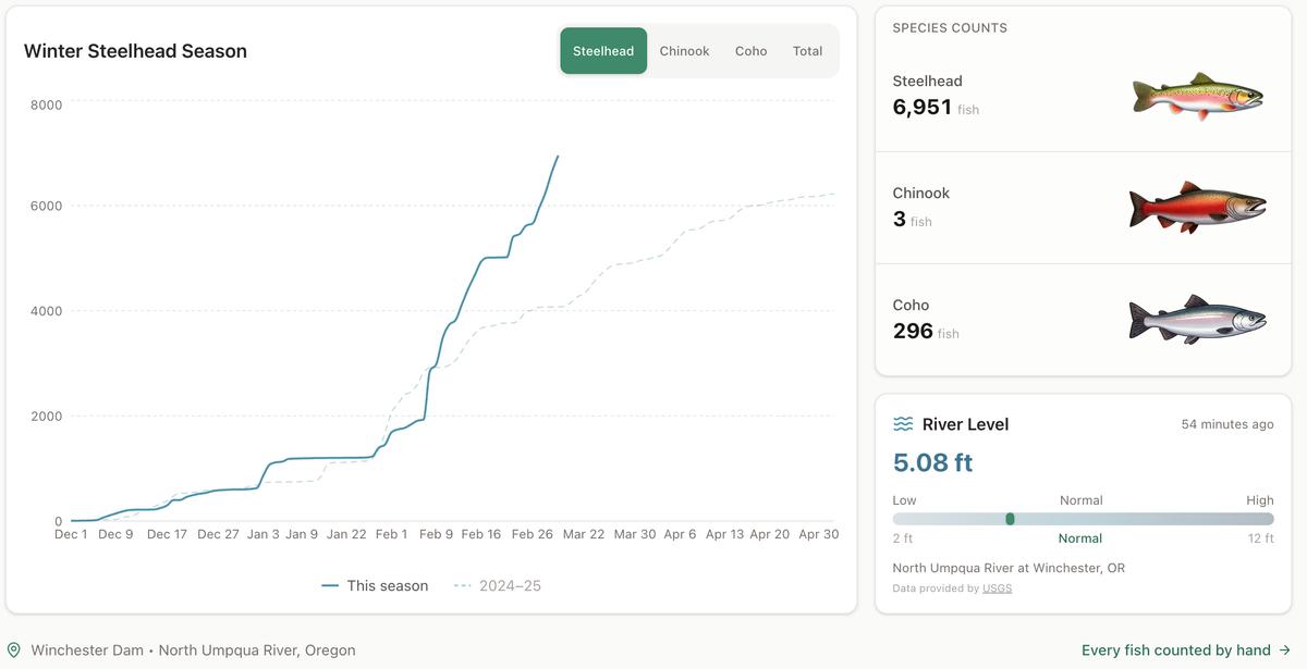
Winter Steelhead Run on the North Umpqua Surpasses Last Year's Total
Nearly 7,000 fish counted at Winchester Dam with two months left in the season
1 min read
Oregon Faces Challenges After Mild Winter
A mild winter has left Oregon with reduced snowpack heading into spring, raising concerns about river levels and insect activity later this year.
1 min read
Stay informed
Get the latest stories from Roseburg Tracker delivered straight to your inbox.