(NWS Medford) Multiple fronts will move through the forecast area from today through the weekend. Mountain passes will be impacted. Snow levels lower tonight but not much precipitation will be left to cause much impact. Snow increases late Friday as a warm front arrives, and travel at elevations above 3000 ft will be impacted, such as Mt Shasta City area on Interstate 5. Snow levels rise late Friday into Sunday morning, up to 6000 ft and higher. Snow levels fall late Sunday, and increasing impacts are expected. Be sure to check the latest road conditions before venturing out and stay up to date with the most recent forecasts. Links for this information are listed below: You can call 511 for Oregon road conditions or for California road conditions call 800-427-ROAD (7623) or visit their websites listed below. Oregon road conditions: http://www.tripcheck.com/ California road conditions:http://quickmap.dot.ca.gov/ NWS hazard viewer:http://www.wrh.noaa.gov/map/?wfo=mfr
Snow Levels Dropping to 2,000 Feet Thursday Night
Related


Stay up to date
Get new posts from Roseburg Tracker in your inbox.
More Stories

In Memory of John Lindsey
John Payne Lindsey, 79, of Roseburg, Oregon, was unexpectedly called home to heaven on Dec. 12, 2025, surrounded by his family. John was born March 19...
2 min read
Roseburg Man Charged With Murder of 11-Month-Old Son
DOUGLAS COUNTY, Ore. – A Roseburg man is in custody tonight charged with the murder of his 11-month-old son. On Sunday, March 15, 2026, shortly befor...
2 min read
K9 Nike to Retire From Winston Police Department
Winston Police Dog Retires After Eight Years of service.
1 min read
Roseburg Cuts Ribbon on New Outdoor Tennis and Pickleball Facility
Roseburg’s rebuilt outdoor Stewart Park complex is now open with eight tennis courts and 10 pickleball courts.
3 min read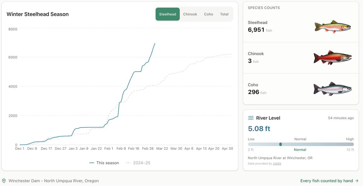
Winter Steelhead Run on the North Umpqua Surpasses Last Year's Total
Nearly 7,000 fish counted at Winchester Dam with two months left in the season
1 min read
Oregon Faces Challenges After Mild Winter
A mild winter has left Oregon with reduced snowpack heading into spring, raising concerns about river levels and insect activity later this year.
1 min read
Stay informed
Get the latest stories from Roseburg Tracker delivered straight to your inbox.