Here is the latest update on the Devil's Knob Complex on Friday morning. Community Meeting: An in person community meeting has been scheduled for August 7, 2021, Saturday at 7:30 PM at the Tiller Volunteer Fire Department. Fire managers from both Devil’s Knob and Skyline Ridge Complexes will provide operational fire updates and an opportunity for the public to ask questions. The Devil's Knob Complex is a grouping of 50 lightning caused fires with the majority burning on the Tiller Ranger District, Umpqua National Forest. The fires were started from thunderstorms on July 29th and August 1st. The Devil’s Knob Complex is situated between the Rough Patch Complex and Jack Fire to the north which is being managed by Northwest Incident Management Team 13 and the Skyline Ridge Complex Fires to the southwest which is being managed by Oregon Department of Forestry Team 1. The Devil's Knob Complex is managed by Northwest Incident Management Team 8 from an incident command post at the Milo Academy near Tiller, Oregon. General Updates: The Devil’s Knob Complex is currently divided into 2 Branches and 6 Divisions to better provide management and oversight of suppression efforts. Fire fighters are scouting for and suppressing small incidents and prioritizing opportunities on larger fires with the highest probability of success. Many of the smaller fires in the complex are reaching full containment and starting mop-up operations. There are 8 larger incidents of concern within the Complex that fire fighters are focusing on based on location and values at risk. Fire acreages will be updated daily. The larger fires include the following: Wildcat Fire - 50 acres and is close to residences 446 Fire - 7 acres, increased activity yesterday is threatening residences in the Beaver Creek area. · Mule Creek Fire - 300 acres Big Hamlin Fires - 200 acres Smith Fire - 140 acres Little Applegate Fire - 150 acres Railroad Fire - 50 acres · Section 30 Fire - 75 acres · Prong Fire – management of this fire has been transferred to the Jack Fire – Rough Patch Complex operation Firefighters are working to construct fireline, mop-up hot spots to secure lines and patrol those fires recently contained. Steep ground and access issues are hindering efforts to establish fireline on several of the fires within the complex. Aircraft is being shared from other near-by Complexes when the air is clear enough for safe flying. An Oregon Army National Guard hoist medivac helicopter will be available as a shared resource if needed. The firefighting resources on the Devil's Knob Complex are also responsible for conducting initial attack operations on the entire Tiller Ranger District. Weather: Today's weather is expected to start out a little hazy in the morning then clearing. Temperatures are also expected to increase 7 – 10 degrees from the previous day's high and the relative humidity will be lower ranging between 30 – 40 percent. Winds will be light. Tonight will be mostly clear with humidity in the 90-95 percent range and temperature lows around 52 degrees. Resources: 3–type 1 hotshot crews, 1 – type 2 IA crew;4-type 2 crews, 28-engines, 5-dozers, 10-water tenders, 2-Falling Modules; 80 – overhead; total resources – 377. Evacuations: The Douglas County Sherriff’s Office has determined the following homes are under a Level 3 “GO!” Evacuation Notice: All homes on Upper Cow Creek Road with addresses starting at 20039 through 20700, and three residences in the Burnt Creek area. Level 3 “GO!” means: LEAVE IMMEDIATELY! The following homes are under a Level 2 “Be Set” Notice: All homes on Upper Cow Creek Road with addresses starting at 18300-20000. Level 2 “Be SET” means: YOU MUST PREPARE TO LEAVE AT A MOMENTS NOTICE. An interactive evacuation map can be found at www.dcso.com/evacuations. Temporary Flight Restrictions: For the safety of the firefighters and aircraft fighting the Devil’s Knob Complex, a temporary flight restriction has been placed over the fire area. Please consult the “Notice to Airman” for specifics. Wildfires are a “No Drone Zone.” Conditions in the forest are very dry. Any spark has a very high probability of starting a new fire so the public is reminded to be extra careful while enjoying the out of doors.
Devil's Knob Complex Now Made Up of 50 Lightning Caused Fires
Related


Stay up to date
Get new posts from Roseburg Tracker in your inbox.
More Stories
 New
NewIn Memory of John Lindsey
John Payne Lindsey, 79, of Roseburg, Oregon, was unexpectedly called home to heaven on Dec. 12, 2025, surrounded by his family. John was born March 19...
2 min read New
NewRoseburg Man Charged With Murder of 11-Month-Old Son
DOUGLAS COUNTY, Ore. – A Roseburg man is in custody tonight charged with the murder of his 11-month-old son. On Sunday, March 15, 2026, shortly befor...
2 min read
K9 Nike to Retire From Winston Police Department
Winston Police Dog Retires After Eight Years of service.
1 min read
Roseburg Cuts Ribbon on New Outdoor Tennis and Pickleball Facility
Roseburg’s rebuilt outdoor Stewart Park complex is now open with eight tennis courts and 10 pickleball courts.
3 min read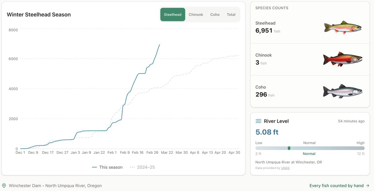
Winter Steelhead Run on the North Umpqua Surpasses Last Year's Total
Nearly 7,000 fish counted at Winchester Dam with two months left in the season
1 min read
Oregon Faces Challenges After Mild Winter
A mild winter has left Oregon with reduced snowpack heading into spring, raising concerns about river levels and insect activity later this year.
1 min read
Stay informed
Get the latest stories from Roseburg Tracker delivered straight to your inbox.