The Poole Fire, the largest fire within the Skyline Ridge Complex has grown to 1,600 acres by Saturday morning. Here is the latest report on the Skyline Ridge Complex and the latest fire boundary maps. Skyline Ridge Complex Update for Saturday, August 7th, 2021 at 9:00 AM Firefighters begin control strategy for largest fire in Complex CANYONVILLE, Ore.—Firefighters are fighting all the fires in the Skyline Ridge Complex with direct action to minimize their spread. That same approach is being used on the southern edge of the largest fire in the Complex – the 1,600-acre Poole Fire, about 6 miles southeast of Days Creek. The northern edge of the fire is far more challenging – three steep ridges run north to south, split by two deep canyons. At the highest point the ridges are over 2,000 feet high, with slopes of 70 to 100 percent. After looking at the difficult terrain, fire managers and private and public landowners have agreed that the best chance of stopping the fire is to build a control line where the ridges converge at a lower elevation. Firefighters are building control lines along existing roads on the tops of the outer east and west ridges. Controlled burns over the next several days will help strengthen those lines to prevent the fire from spreading east or west. Newly arriving resources are being directed to this effort, including 100 more firefighters who arrived yesterday. Ten helicopters continue helping suppress fires in the Complex. The second largest fire in the Complex is the 190 acre O’Shea Fire a few miles southeast of Canyonville. Most other fires are two acres or less. PNW Team 8 will host an in-person community meeting at Tiller Fire Station tonight at 7:30 p.m. ODF Team 1 will then host a virtual community meeting on Facebook Live Sunday at 7:30 p.m. Incident Commander Joe Hessel said, “Our highest chance for success in stopping the Poole Creek Fire with the lowest risk to our firefighters is to bring it north along the ridges, out of the canyons, to a strong, defensible control line.”
Poole Fire Grows to 1,600 Acres SE of Days Creek
Related


Stay up to date
Get new posts from Roseburg Tracker in your inbox.
More Stories
 New
NewIn Memory of John Lindsey
John Payne Lindsey, 79, of Roseburg, Oregon, was unexpectedly called home to heaven on Dec. 12, 2025, surrounded by his family. John was born March 19...
2 min read New
NewRoseburg Man Charged With Murder of 11-Month-Old Son
DOUGLAS COUNTY, Ore. – A Roseburg man is in custody tonight charged with the murder of his 11-month-old son. On Sunday, March 15, 2026, shortly befor...
2 min read
K9 Nike to Retire From Winston Police Department
Winston Police Dog Retires After Eight Years of service.
1 min read
Roseburg Cuts Ribbon on New Outdoor Tennis and Pickleball Facility
Roseburg’s rebuilt outdoor Stewart Park complex is now open with eight tennis courts and 10 pickleball courts.
3 min read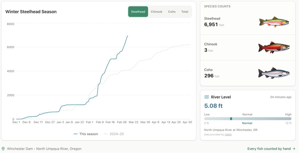
Winter Steelhead Run on the North Umpqua Surpasses Last Year's Total
Nearly 7,000 fish counted at Winchester Dam with two months left in the season
1 min read
Oregon Faces Challenges After Mild Winter
A mild winter has left Oregon with reduced snowpack heading into spring, raising concerns about river levels and insect activity later this year.
1 min read
Stay informed
Get the latest stories from Roseburg Tracker delivered straight to your inbox.