Another heat wave is set to arrive in Douglas County this next week with temperatures over 100 degrees for possible five straight days. Temperatures will begin to heat up on Monday in the low 90's and likely peak on Wednesday and Thursday with temps as high as 105 degrees. High temperature forecast for Roseburg: Monday August 9 - 92 degrees Tuesday August 10 - 101 degrees Wednesday August 11 - 105 degrees Thursday August 12 - 105 degrees Friday August 13 - 101 degrees Saturday August 14 - 100 degrees Here is the latest from NWS in Medford about the heat wave: "A heat wave will begin to be felt Monday night as west side valleys south of the Umpqua divide struggle to cool off below 60 degrees. Tuesday, pending impacts from smoke, temperatures will climb near triple digits. For Medford the probability of reaching 100 degrees is 68%, while at Roseburg that chance is 54%. By Thursday, these probabilities increase to 98% and 83% respectively. For west side valleys south of the Umpqua divide, overnight lows greater than 65-69 degrees begin to increase the chances for heat related impacts. At Medford and Montague, the chance to have lows at or above 65 degrees are 56% & 79%, and 43% & 54% on Tuesday and Wednesday night. To the north, at Roseburg, cooler lows bring similar heat related impacts due to a slightly more mild climate. Chances of overnight lows greater than 65 at Roseburg are 64% and 78%. Hopefully this helps to show how far reaching this heat wave will be. It`s also worth mentioning that similarly hot temperatures will be felt in areas both to the north and south along the I-5 corridor. Two places that could be spared the excessive heat are the coast and areas east of the Cascades. Confidence is fairly high that the coast will remain cool. Highs typically need to reach 80 degrees and lows in the mid-to-upper 60s before heat related impacts become a concern. Neither of which are forecast. The other area is east of the Cascades, though confidence is much lower. High temperatures in the mid-to-upper 90s certainly are concerning when they are prolonged as is expected. However, temperatures are forecast to cool off far more. Lows typically need to be warmer than 62 degrees before concern increases and the probability at Lakeview of lows greater than this peak at 6%. A heat advisory may still need to be considered, but for now it appears only the west side will need heat related headlines. As the ridge begins to break down, the chance for thunderstorms creeps back into the forecast. There is reasonable temporal agreement in the EPS and GEFS for monsoonal moisture to move into the area starting around Friday of next week. Probabilities of PWs greater than 1" are expectedly low at this time, 10-30% in N. Cal., along and east of the Cascades. Not surprisingly the best chances for thunderstorms are along and east of the Cascades with a bullseye of 12 to 18 % in the Chemult area, a spot with very high density counts of lightning in the month of August. Another area to watch are Tstorm probabilities of 10-16% over Central Siskiyou County. This was where the PW probability of 1" was around 30% and matches a climatologically significant area of lighting activity from July into August. Ensembles are showing good dispersion, with means well centralized amongst the model solutions, so would expect the thunderstorm forecast to begin coming together with reasonable certainty in the next 24-36 hrs.
Another Heatwave to Arrive in Oregon Next Week
Related


Stay up to date
Get new posts from Roseburg Tracker in your inbox.
More Stories
 New
NewIn Memory of John Lindsey
John Payne Lindsey, 79, of Roseburg, Oregon, was unexpectedly called home to heaven on Dec. 12, 2025, surrounded by his family. John was born March 19...
2 min read New
NewRoseburg Man Charged With Murder of 11-Month-Old Son
DOUGLAS COUNTY, Ore. – A Roseburg man is in custody tonight charged with the murder of his 11-month-old son. On Sunday, March 15, 2026, shortly befor...
2 min read
K9 Nike to Retire From Winston Police Department
Winston Police Dog Retires After Eight Years of service.
1 min read
Roseburg Cuts Ribbon on New Outdoor Tennis and Pickleball Facility
Roseburg’s rebuilt outdoor Stewart Park complex is now open with eight tennis courts and 10 pickleball courts.
3 min read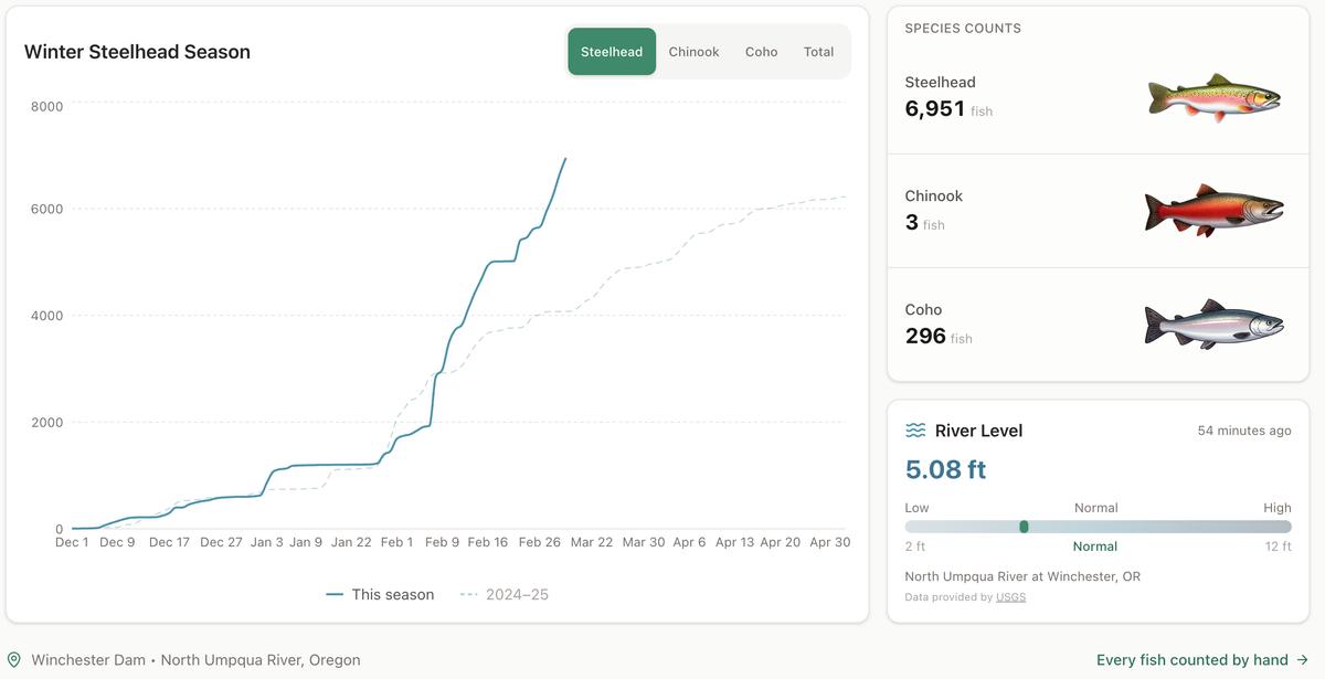
Winter Steelhead Run on the North Umpqua Surpasses Last Year's Total
Nearly 7,000 fish counted at Winchester Dam with two months left in the season
1 min read
Oregon Faces Challenges After Mild Winter
A mild winter has left Oregon with reduced snowpack heading into spring, raising concerns about river levels and insect activity later this year.
1 min read
Stay informed
Get the latest stories from Roseburg Tracker delivered straight to your inbox.