The calendar says it's been autumn for nearly a month. But, we've been hard-pressed to find anything resembling fall with temperatures remaining quite summer-like for all of October so far. In fact, we've had the warmest start to October (through 17 days) ever. We've averaged 88.9F for MaxT, which is 1.3F higher than the first 17 days of October 1991, which saw average MaxTs of 87.6F. My garden is still producing beans and my tomatoes have been amazing! And, despite a brief taste of fall near the equinox (remember that? -- me neither), September was very warm as well. The last time temperatures were below normal was September 20th, the day we set a 24-hour rainfall record (0.43 inches). Seems like long ago. Well, the next few days won't be any different with high temperatures about where they have been all month -- in the 80s south of the Umpqua Divide (Rogue/Illinois Valleys) and into western Siskiyou County with upper 70s to low 80s elsewhere, except along the coast where marine air will keep things slightly cooler. Take it in though because a big change is expected late this week and especially this weekend as we are seeing a major pattern shift toward cooler, wetter weather that will begin Friday. The upper ridge that has been persistent all month is now east of the area, only slightly bending (not breaking) as an upper trough approached the coast yesterday. The trough is now splitting with a closed low developing off the California coast. Guess what happens next? The upper ridge rebuilds (no!). This will bring another shot at record high temperatures on Wednesday/Thursday. We are predicting 87F in Medford on Wednesday (record 83F set in 1999) and 85F on Thursday (record 85F set in 2018). Other records may be challenged in NorCal and east of the Cascades. This time, however, the upper ridge should only rebuild briefly as the flow across the North Pacific accelerates with a 170+ kt jet taking shape near/just south of the Aleutians. An upper disturbance flattens the ridge Thursday night (the ridge actually retrogrades offshore) leading to cooling area wide on Friday. We aren't quite expecting precipitation yet though, since this trough will not have much moisture with it. By late Friday/Fri night, a much more energetic disturbance will take aim on the PacNW with a sharp cold front sweeping across SW Oregon and NorCal Friday night into Saturday morning. This front will bring widespread wetting rainfall, with the most precipitation occurring from the Coast to the Cascades. Amounts of 0.75-1.50" will be common in those areas, with lesser amounts in the usual downslope areas (west side valleys south of the Umpqua Divide). Rain amounts will also be much lower south and east of the mountains, but still probably the first appreciable rainfall there since mid-September. Snow levels will drop considerably with the front, so snow will likely be falling over the higher terrain of the Cascades by Saturday morning. Accumulations should be held in check, however, due to recent warmth and early season warm ground temperatures. The upper trough will swing through keeping things showery Saturday. There could even be a rumble of thunder near or north of Roseburg. This will be the coolest day in some time with high temperatures struggling to get out of the 50s over the west side and much above 50F east of the Cascades. Depending on how much clearing we get Saturday night, some areas west of the Cascades could see their first temperatures readings down into the frost/freeze range. Clouds will be a limiting factor though with NBM probability of <=36F in Medford standing at only 24%. At this point, however, it's amazing that we've made it this long. Average first frost in Medford is October 4 (<36F) and first freeze (<=32F) is October 19. This first trough will exit to the east of the area Sunday and showers will probably end, except in the mountains and areas NW of the Umpqua Divide, where onshore flow could keep some showers going. Precip chances dwindle to <30% here in the Rogue Valley, so despite it being cool, most of the day will likely be dry. Another frontal system will approach and move into the area Sunday night into Monday. This one doesn't look quite as strong, but could bring another shot at rain early next week. While brief ridging may set up again next Monday night into Tuesday, the Pacific jet should send another disturbance our way by midweek. Via NWS Medford -Spilde
Much Cooler/Wetter Weather Arriving Friday
Related


Stay up to date
Get new posts from Roseburg Tracker in your inbox.
More Stories
 New
NewIn Memory of John Lindsey
John Payne Lindsey, 79, of Roseburg, Oregon, was unexpectedly called home to heaven on Dec. 12, 2025, surrounded by his family. John was born March 19...
2 min read New
NewRoseburg Man Charged With Murder of 11-Month-Old Son
DOUGLAS COUNTY, Ore. – A Roseburg man is in custody tonight charged with the murder of his 11-month-old son. On Sunday, March 15, 2026, shortly befor...
2 min read
K9 Nike to Retire From Winston Police Department
Winston Police Dog Retires After Eight Years of service.
1 min read
Roseburg Cuts Ribbon on New Outdoor Tennis and Pickleball Facility
Roseburg’s rebuilt outdoor Stewart Park complex is now open with eight tennis courts and 10 pickleball courts.
3 min read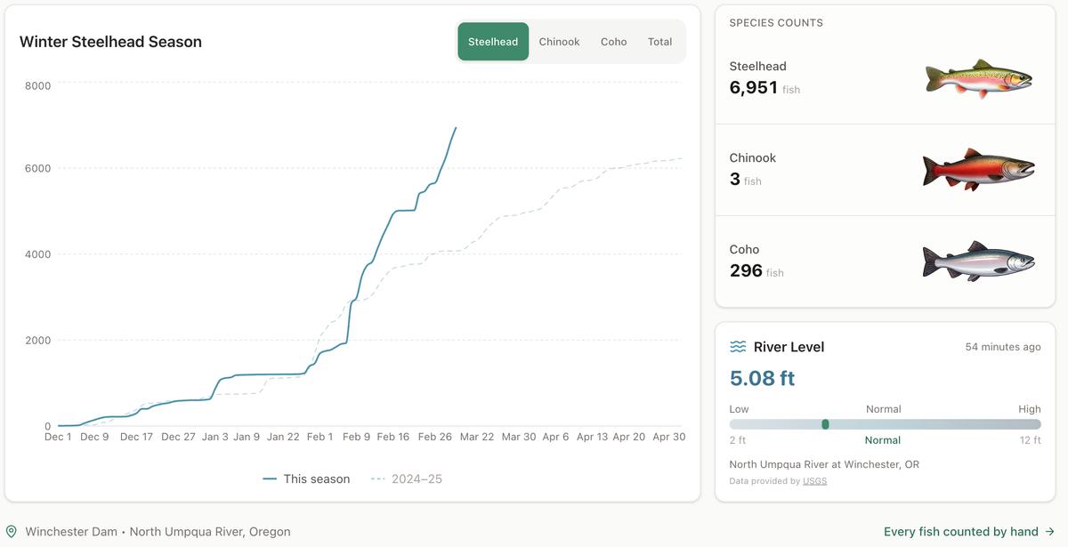
Winter Steelhead Run on the North Umpqua Surpasses Last Year's Total
Nearly 7,000 fish counted at Winchester Dam with two months left in the season
1 min read
Oregon Faces Challenges After Mild Winter
A mild winter has left Oregon with reduced snowpack heading into spring, raising concerns about river levels and insect activity later this year.
1 min read
Stay informed
Get the latest stories from Roseburg Tracker delivered straight to your inbox.