Oregon Department of Environmental Quality has extended an Air Pollution Advisory...in effect for Douglas County into Friday afternoon. The Cedar Creek Fire near Oakridge combined with periods of easterly and northerly winds will cause smoke concentrations to increase. Air Quality is expected to reach unhealthy levels at times within Douglas County. Here is the latest forecast discussion from the NWS in Medford SYNOPSIS...Southern Oregon and northern California will remain under the influence of a ridge of high pressure that will bring cool to chilly mornings and warm afternoons through the end of the week. Then, fall arrives with much cooler and wetter weather with lowering snow levels as a parade of troughs move through the area this weekend with the weather remaining unsettled next week. KEY POINTS: *This will be the first rain on roads in a few weeks, therefore it is recommended to use extra caution on the roads to account for excess oil build up. *Wetting rains are likely for much of our area, and may be enough to either dampen or conclude fire season. *Those with agricultural interests west of the Cascades should consider harvesting their summer crops by Friday or Saturday. Discussion: Satellite imagery is showing some high clouds in Siskiyou and Modoc Counties, with clear skies elsewhere. Some haze from lingering smoke from the Cedar Creek Fire remains over a large area of southern Oregon and northern California. This is all part of a ridge of high pressure that remains over the area. With this influence, expect some mild to chilly mornings and warm afternoons. Ensembles suggest that we may see some record challenging warmth for inland areas on Wednesday and Thursday afternoons. This will continue through Friday before things begin to transition to more of a fall pattern. On Friday, a first front will split our ridge and begin to break it down, bringing in some breezier winds to areas east of the Cascades ahead of a secondary front which is now expected to arrive Friday night. This second front is expected to be relatively wet as it brings in wetting rains to a large portion of southern Oregon and some of northern California. Snow levels will start off around 9000 feet (from the summer pattern) and drop to around 5000 feet on Saturday. Another impulse comes through on its heels to further drop the snow levels to 4000 feet by Sunday in showers. Another impulse then follows suit on Monday with additional showers for the area. In all, this precipitation appears to be relatively gratuitous; and it will have the potential to finally end fire season. Snow accumulations should be held in check, however, due to recent warmth and early season warm ground temperatures. Depending on how much clearing we get Saturday night, some areas west of the Cascades could see their first temperatures readings down into the frost/freeze range. Clouds will be a limiting factor though with NBM probability of <=36F in Medford standing at only 24%. At this point, however, it's amazing that we've made it this long. Average first frost in Medford is October 4 (<36F) and first freeze (<=32F) is October 19. Ensembles begin to diverge after that with some ensembles clustering around a more progressive solution with additional fronts and systems arriving Tuesday night into Wednesday with others trying to rebuild the ridge on Tuesday and having the next system come in on Thursday or Friday. Either way, it appears as if fall has arrived finally, and that we are finally starting to move more squarely into the wet season, which is good considering November and December tend to be our wettest months of the year. Via NWS in Medford
Hazy Conditions Through Friday, Then Fall Arrives
Related


Stay up to date
Get new posts from Roseburg Tracker in your inbox.
More Stories

K9 Nike to Retire From Winston Police Department
Winston Police Dog Retires After Eight Years of service.
1 min read
Roseburg Cuts Ribbon on New Outdoor Tennis and Pickleball Facility
Roseburg’s rebuilt outdoor Stewart Park complex is now open with eight tennis courts and 10 pickleball courts.
3 min read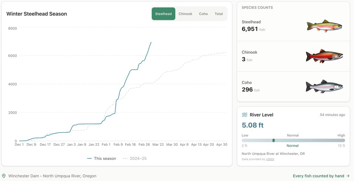
Winter Steelhead Run on the North Umpqua Surpasses Last Year's Total
Nearly 7,000 fish counted at Winchester Dam with two months left in the season
1 min read
Oregon Faces Challenges After Mild Winter
A mild winter has left Oregon with reduced snowpack heading into spring, raising concerns about river levels and insect activity later this year.
1 min read
Man Presumed Drowned in South Umpqua River
ROSEBURG, Ore. – A man is presumed drowned following an incident in the South Umpqua River on Friday. On Friday, February 27, 2026, at approximately ...
1 min read
Olsrud Family to Sell Sherm's Markets and Grocery Stores
The Olsrud family, which has owned and operated Sherm's Markets since 1967, is planning to sell the company, including its four Southern Oregon grocer...
2 min read
Stay informed
Get the latest stories from Roseburg Tracker delivered straight to your inbox.