A winter storm will impact our region Thursday morning into Friday afternoon. Snow levels are expected to range from 3000 to 3500 feet Thursday, falling to around 1000 feet Thursday night then rising to around 2000 feet Friday afternoon. The heaviest snow will fall in the Coastal Mountains, western Siskiyou County, eastern Douglas County, and especially the southern Oregon Cascades. West winds at 15 to 25 mph with gusts of 25 to 40 mph will accompany the snow. If you have travel plans this weekend, be prepared for wintry conditions. There is a small chance of snow at the valley floors at times on Friday and early Saturday morning. Here's the latest forecast discussion from the NWS in Medford - Issued 4:45 AM PDT Thu Mar 23 2023 SHORT TERM: Today through Friday. A Winter Storm Warning and Winter Weather Advisory remains in effect later today into Friday for most of the west side above 1500 feet, and the higher terrain of northern and eastern Klamath County and western Lake County. Precipitation is currently limited to light scattered snow showers over the southern Oregon Cascades. That will change in a few hours as a cold front brings rain to the coast. The front will track across the area with rain and snow today. Precipitation is expected to reach the Cascades by noon then develop across the east side into this evening. The most intense rates of precipitation will occur with the frontal passage. Snow levels will begin around 3000 to 3500 feet, then fall to around 1000 feet tonight behind the front with precipitation transitioning to showers. Westerly low level flow tonight through Friday will bring the highest amounts to upslope portions of the higher terrain of southwest Oregon. This includes eastern Curry, western Josephine, eastern Douglas, and eastern Jackson County. Totals of 12 to 24 inches are expected in the southern Oregon Cascades, 6 to 12 inches in the Kalmiopsis Wilderness, Siskiyou Mountains, and northern California Cascades, and 3 to 6 inches for the higher terrain of the east side (including Highway 97 north of Chiloquin). LONG TERM: Friday night through Wednesday. A pretty impressive winter weather pattern persists across the region. We're expecting cold northwest flow to persist behind the cold front from Friday night into Saturday. 850 mb temperatures will likely be around -5 to -6 C. Air this cold is usually supportive of snow in the valleys west of the Cascades during the winter. We do have snow in the forecast for the valley floors Friday night into Saturday morning. This will mostly be dependent if a showers can hold together as the move off the mountains into the valleys. Nonetheless, don't be surprised to see snow on the grass Saturday morning. By Saturday, the axis of the low enters southern Oregon. This will promote an unstable atmosphere and pockets of convective available potential energy (CAPE). With a more showery pattern, temperatures in some of the valleys will warm up into the mid 40's. Lapse rates are up to 8C/km up to 650 mb, which is rather unstable. All these things considered, one should expect plenty of shower activity with the low chance of a rumble of thunder across the region. With regards to snow accumulating from Thursday up until Saturday afternoon, we're looking at up to 2 feet of snow over the Cascades. This seems reasonable given the persistent westerly flow that favors the west to east sloping Cascades from Thursday even into Saturday. The coastal range will also be under focus here as these convective showery patterns produce a lot of snow in the Kalmiopsis wilderness. By Saturday night into Sunday, high pressure begins to build over the forecast area as the upper level low departs. Models still have a 30 to 50 percent chance of rain along the coast and the higher Cascades with drier conditions farther to the east. There are some models disagreements with how Sunday pans out. The NBM currently shows those PoP chances spreading eastwards into the day Sunday, which goes against what some of the deterministic models show right now. This is probably due to how the models are handling the next system. Right now, it's looking like Monday into Tuesday is the best time for weather impacts with this low. The snow percentiles show 18 inches in the 75th percentile for Mt. Shasta City. Consequently, there is also 3 inches in the 25th percentile for that same area. That rather large spread suggests that the track of this low For latest road conditions by ODOT- https://tripcheck.com/
Late Winter Storm to Bring Heavy Snow to Cascades
Related


Stay up to date
Get new posts from Roseburg Tracker in your inbox.
More Stories

In Memory of John Lindsey
John Payne Lindsey, 79, of Roseburg, Oregon, was unexpectedly called home to heaven on Dec. 12, 2025, surrounded by his family. John was born March 19...
2 min read
Roseburg Man Charged With Murder of 11-Month-Old Son
DOUGLAS COUNTY, Ore. – A Roseburg man is in custody tonight charged with the murder of his 11-month-old son. On Sunday, March 15, 2026, shortly befor...
2 min read
K9 Nike to Retire From Winston Police Department
Winston Police Dog Retires After Eight Years of service.
1 min read
Roseburg Cuts Ribbon on New Outdoor Tennis and Pickleball Facility
Roseburg’s rebuilt outdoor Stewart Park complex is now open with eight tennis courts and 10 pickleball courts.
3 min read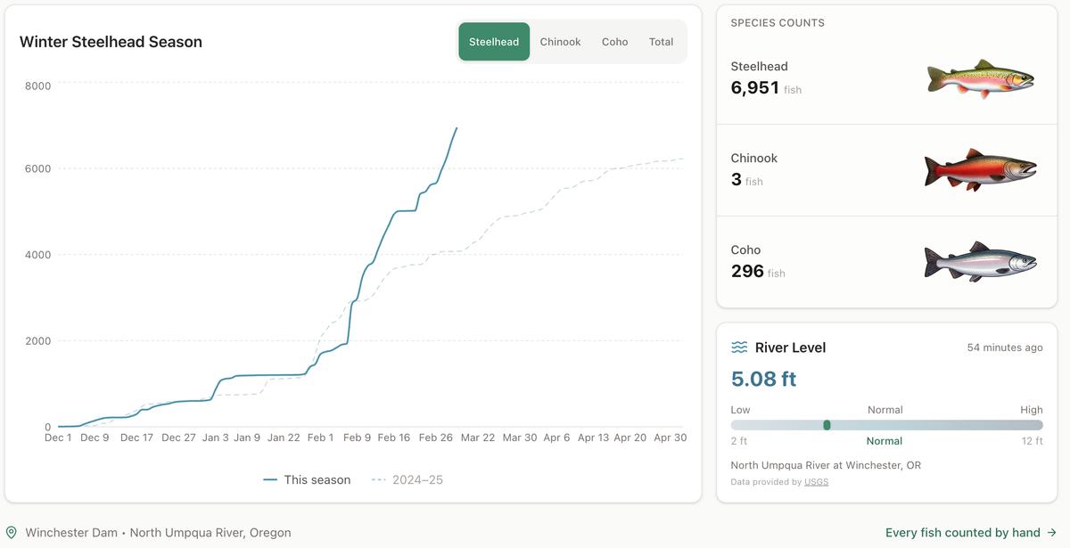
Winter Steelhead Run on the North Umpqua Surpasses Last Year's Total
Nearly 7,000 fish counted at Winchester Dam with two months left in the season
1 min read
Oregon Faces Challenges After Mild Winter
A mild winter has left Oregon with reduced snowpack heading into spring, raising concerns about river levels and insect activity later this year.
1 min read
Stay informed
Get the latest stories from Roseburg Tracker delivered straight to your inbox.